Aerial View Land’s End Then and Now

Left: Circa 1960 • Exact date unknown Land’s End, Divorce Beach, Solmar Beach andPlaya el Médano Cabo San Lucas in the early years. Photo by James R. Stewart © Regents of the University of California Right: September 06 2012 Land’s End, Divorce Beach, Solmar Beach, Playa el Médano, the growing town, and a cruise ship sitting in the Cabo San Lucas harbor. OldCabo.com • LosCabosMagazine.com • LosCabosGuide.com
Left: Circa 1960 • Exact date unknown. Land’s End, Divorce Beach, Solmar Beach andPlaya el Médano Cabo San Lucas in the early years. Photo by James R. Stewart © Regents of the University of California
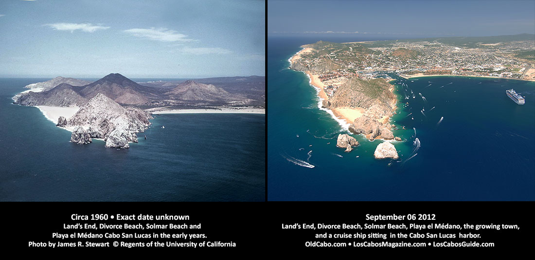
Right: September 06 2012. Land’s End, Divorce Beach, Solmar Beach, Playa el Médano, the growing town, and a cruise ship sitting in the Cabo San Lucas harbor.
OldCabo.com • LosCabosMagazine.com • LosCabosGuide.com

Below is an older version of similar images.

aerial-cabo-beach-bay-2222-2012-set
Aerial view of Land’s End , Harbor and Playa el Médano (Medano Beach) Cabo San Lucas. Image on Left: date and source unknown – estimated c1950s. Image on right: September 06, 2012 © Joseph A. Tyson OldCabo.com • LosCabosMagazine.com • LosCabosGuide.com

Does anyone have any information about the image on the left above?  This aerial view of Land’s End at Cabo San Lucas was found on the internet but I have not been able to exactly identify the date it was taken,  the source of the image or the owner.  Any information would be appreciated.

aerial-photo-lands-end-pre-hotels-c1950s-2

This is another version of the Land’s End  image from the internet. This shows more of Medano Beach.  Exact date taken and  the source of the image or the owner is unknown.