San Jose del Cabo 1800’s

USS_Dale_San_Jose_del_Cabo_MexicoWatercolor drawing of  the USS Dale off the coast of San Jose del Cabo in 1847 during the Mexican-American War. By Seaman William H. Meyer.  Source = The Webzine for Traveling and Living in Baja California ©2004-2009 GFDL Desert Digital LLC

William H. Meyers, watercolor, 1847. Naval Sketches of the War in California, limited Edition of 1,000, Grabhorn Press, San Francisco, 1939. The USS Sloop Dale off San Jose del Cabo, the extreme lower point of Lower California. 18 November 1846.  From the collection of Franklin Delano Roosevelt.
William H. Meyers, watercolor, 1847. Naval Sketches of the War in California, limited Edition of 1,000, Grabhorn Press, San Francisco, 1939.
The USS Sloop Dale off San Jose del Cabo, the extreme lower point of Lower California. 18 November 1846. From the collection of Franklin Delano Roosevelt.

William H. Meyers, watercolor, 1847. Naval Sketches of the War in California, limited Edition of 1,000, Grabhorn Press, San Francisco, 1939. The USS Sloop Dale of San Jose, the extreme lower point of Lower California. 18 November 1846. From the collection of Franklin Delano Roosevelt.

USS_Dale_(1839)USS Dale (1839) (later Oriole) was a sloop-of-war in the United States Navy commissioned on 11 December 1839. Dale was involved in the Mexican-American War, the American Civil War, operations along Africa to suppress slave trade, and was used in the US Coast Guard, among other activities.
https://en.wikipedia.org/wiki/USS_Dale_%281839%29

Mexican / American War of 1846 to 1848
The history of the Mexican / American War of 1846 to 1848 in Baja California is often forgotten. This is due to the fact that the war and most of the more sensational battles were fought in the interior of Mexico. But some little know facts about the war in Baja California. Read more at:  https://www.bajainsider.com/article/mexican-american-war-baja-california-sur

Island of California Map

An early map of California by Joan Vinckeboons, an employee of the Dutch West India Company. The geography of the West Coast, and particularly the Baja peninsula, contributed to an early European misconception, from the 16th century onward, that California was an island. This myth was  debunked in the 18th century.

California-island-Vinckeboons5-1200px
Map of California as an island. Ink and watercolor with pictorial relief. Date circa 1650 | Source: Library of Congress | Author: Joan Vinckeboons Dirt, scratches, and stains removed. Water damage corrected. Depigmented areas repigmented. Colors adjusted, with very extensive local adjustments to color balance, brightness, and contrast. Histogram not changed.

Johannes Vingboons [Public domain], via Wikimedia Commons
https://commons.wikimedia.org/wiki/File:California_island_Vinckeboons.jpg

——-

Ferdinand Konščak, a Croatian, (variously also Fernando Consag, Konsag, Konschak, etc.) (December 2, 1703 – September 10, 1759)
was a Jesuit missionary, explorer, and cartographer.

Konščak was born in Varaždin, Croatia, and attended primary and secondary school in his native city. At sixteen he finished the expected grades and was admitted to the novitiate of the Society of Jesus in Trenčín, Slovakia, In 1729, Konščak left for Cádiz in Spain, then went to North America, where he was active as a missionary on New Spain’s Baja California peninsula (today part of Mexico), from 1732 to the end of his life. His headquarters was at Mission San Ignacio. From 1748 he acted as the superior of the mission and later, in 1758, inspector of all missions in Baja California. Konščak spoke various dialects of the local Cochimí language.

He directed and oversaw the building of new missions, aqueducts, embankments, drainage channels, and the first silver mines. He died at San Ignacio in 1759.  On the basis of the data obtained, Konščak made a precise map of Baja California (1748) and a map of the Gulf of California (around 1750). In June and July 1746 he was sent by sea to the head of the Gulf of California in order to investigate the disputed question of whether Baja California was an island. Although he closely followed the coast and reached the Colorado River, the issue continued to be in dispute for nearly another three decades .

There is an outcrop in the northern Gulf of California named Roca Consag, located offshore near San Felipe. Konščak discovered many water springs so that even today there are shops and other facilities in California bearing his name like  “Licores Konsag”.

The above “Baja Island” correction furnished by one of our knowledgeable readers, a Croatian / Mexican,  courtesy of The Latitude 22 Road House.

24156-01


Cabo San Lucas during the 1940’s

These images were taken from a video made in the late 1940’s. The video link is later in this post.

Baja California : The Pacific Coast Of Mexico – 1949 Travelogue / Educational Documentary

Scene from Baja California : The Pacific Coast Of Mexico – 1949 Travelogue / Educational documentary film.

This educational documentary film shows beautiful color footage of old Baja, travelling from Ensenada to Cabo San Lucas, with stops at the waterless village of Magdalena Bay, Tortuga Bay, and the vineyards at Santo Tomás. Cabo San Lucas is featured in the last two minutes.

12748948

San Jose del Cabo 1950’s

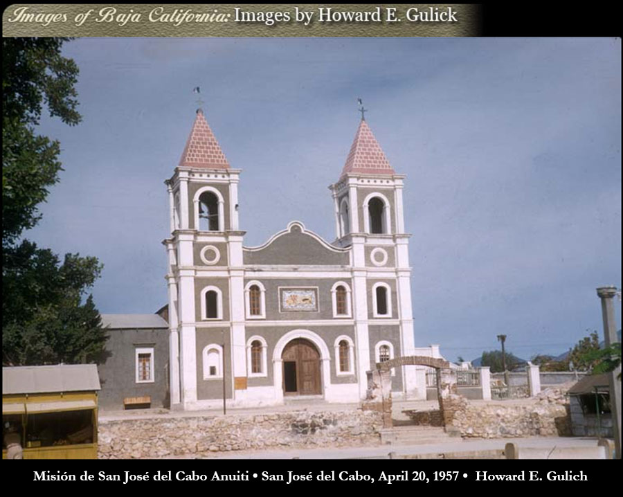
church-san-jose-del-cabo-gulick-1957
Misión de San José del Cabo Anuiti • San José del Cabo, April 20, 1957 • Photo by Howard E. Gulich


San José del Cabo power plant building in 1957. Photo by Howard E. Gulick.


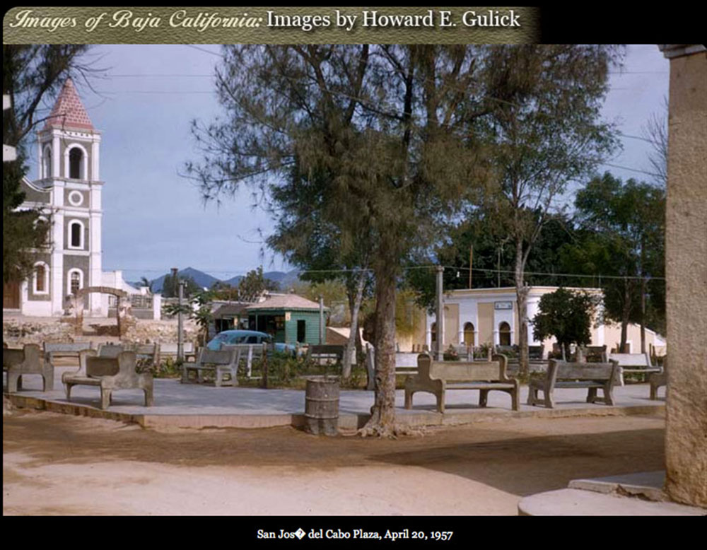
San Jose del Cabo town square, April, 1957. Photo by Howard E. Gulick.


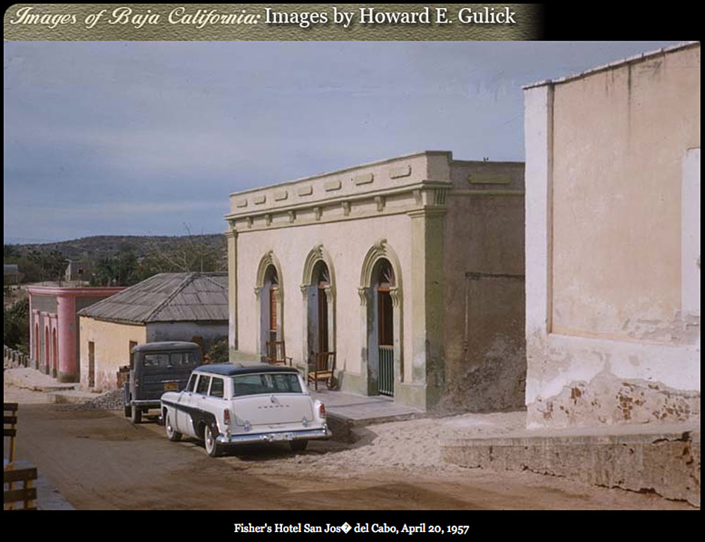
san-jose-del-cabo-hotel-apr-1957-gulick
Hotel de Los Pescadores, (Fisherman’s Hotel)  San Jose del Cabo, April 1957. Photo by Howard E. Gulick.


Municipio de San José del Cabo (town hall) 1957. Photo by Howard E. Gulick.


san-jose-del-cabo-street-1957-gulick
Street scene and buildings in San José del Cabo, April 20, 1957. Photo by Howard E. Gulick.